Takamagahara Onsen in Toyama Prefecture certainly earns its title of being Japan’s most remote hot spring. Before you’ve even started hiking, you feel a sense of isolation—seeing as the trailhead is a one-hour drive from the nearest village, on a lonely road (which is closed half the year) through mountain tunnels winding up to Arimine Dam. From that point to actually reaching the hot spring, it’s a good three to four days (roundtrip) of fairly challenging hiking.
The journey, however, is spectacular. Being so remote means unsoiled nature, crystal-clear mountain streams, views of mountains far off in the distance, and—apart from your fellow hikers—no signs of civilization in any direction. You will of course need to leave behind any plans to livestream your progress or post daily Instagram bear selfies as there’s absolutely no phone reception after just a short while into the hike (and, yes, there may be bears).

The terrain varies between steep paths through the forest, gentle walking over wooden planks across plateaus, and hopping across boulders along a river. Much of the hike has sparse tree cover or is across open plateaus, so this route has some spectacular views even though you don’t really summit any mountain.
You shouldn’t attempt this journey without thorough preparation and an experienced hiker in your group. This 3.5-day itinerary should be fairly comfortable for anyone who’s reasonably fit. Experienced hikers could complete the hike in three or even two days, but as public transport options are limited you’d need to come by car.
Also note this itinerary is limited to a few months from June to late October, depending on the opening dates of the mountain huts and the public transport.
Preparation
Be sure to plan your trip carefully. One of the downsides of hiking to Japan’s most remote hot spring is there’s no chance of picking up things you forgot at shops along the way.
What to bring
Weather conditions can vary dramatically, and so you should be prepared for blistering sun, torrential rain and fog. That is, bring sunscreen, a rain jacket (waterproof, not just water-resistant), waterproof hiking boots and a head lamp. Also, a bear bell.
Bring a GPS or use a smartphone app (like YAMAP) that can download maps in advance and use the built in GPS to trace your progress. Note there is no phone signal at all for most of the hike, but GPS should be fine. There’ll be no opportunity to charge phones/cameras, etc. thoguh, so you’ll want to bring a battery-powered USB charger.
Also, it’s essential to bring a paper hiking map of the area like this one —don’t only rely on digital devices or your sense of direction!
And of course bring your favorite snacks, as there’s only a limited selection of snacks for sale at the mountain huts along the way.
Accommodation

Booking
For accommodation, I recommend you take the easy option and stay at the yamagoya (mountain lodges/huts) as opposed to camping. You’ll need to book them in advance and they are all booked via the same company Lodge Taro. Although there’s a booking form, it is in Japanese so it’s probably best to send a message via their general contact form as they can communicate in English via email.
When booking, it’s best to request dinner, breakfast and bento (packed lunch, which is usually a couple of rice balls and pickles)—that way you’ll need to carry less food.
With this itinerary you’ll stay at the lodges as follows:
Night 1: Yakushizawa Yamagoya
Night 2: Takamagahara Sanso
Night 3: Tarodaira Yamagoya
Yamagoya tips and etiquette
If you’ve never stayed at a mountain lodge in Japan, here are a few tips:
- If possible, avoid going at peak times (like weekends), as you might have to share a futon with someone if it’s busy.
- Aim to arrive by 4 pm. Dinner is usually served quite early, like 5:30 pm
- During the night, expect to hear plenty of fidgeting, digging in rucksacks, snoring and toilet visits—so if you’re a light sleeper bring ear plugs.
- Expect an early night and an early start, usually it’s lights out by 8 pm–9 pm, and breakfast at 5:30 am–6 am.
- If you have any dietary requirements, mention them when booking as they may be able to accommodate given enough notice.
- The mountain huts also make good lunch spots. Kumanodaira Lodge in particular smokes their own bacon and bakes rye bread.
Tip: The night before the hike, consider booking a hotel/hotel near Toyama Station. That’s the simplest way to ensure you’ll catch the 6:10 am bus to the trailhead on time. (Hardcore cheapos traveling in from Tokyo will of course take the overnight bus instead to save on lodging costs.)
Getting to the trailhead
There’s a sparse bus service from Toyama to the trailhead, which you should book in advance (I didn’t and ended up having to take a taxi). The booking website is Japanese only, so it might be easier to get someone who can speak Japanese to call and reserve the bus seats for you. If you do manage to book using the website, you’ll still need to pay for the tickets at a convenience store, the confirmation email will have an 11-digit booking number looking something like this:
予約番号:09128058411
In the email there should be a link to instructions on how to pay at a convenience store, though getting the convenience staff to help (showing them the email of course), might be simpler. It’s basically a case of going to the “Loppi” machine at a Lawson/Family Mart, clicking the “各種番号” button, entering the reference “BUS”, then entering your 11-digit number.
The bus you want leaves Toyama Station at 6:10 am and arrives at Oritate car park at 8:10 am. There’s also a later bus service departing from Arimineguchi train station, but catching the earlier bus is strongly recommended.
And don’t forget to book the bus back!
Alternatively, the Chitetsu Taxi service costs ¥19,100 one way, which if you’re a party of three or four is actually very good value considering the distance and altitude change. You’ll probably need a Japanese speaker to help when calling.
If you’re coming by car, there’s a free car park at Oritate, which can get quite busy during peak times, in which case you might end up parking on the grass. Note the access road is closed between 8 pm and 6 am, so make sure you get back to your car well beforehand.
The hike
Please use a proper map and GPS when hiking. The following guidelines are just an overview and will be woefully inadequate if the weather takes a turn for the worse.

Day 1
Arrive at Oritate bus stop around 8 am–9 am.
The first leg takes 4 to 5 hours to hike from the trailhead up to the ridge. There’s a single path up from the Oritate parking area (the narrow entrance by the map). It’s quite a steep path initially, through a mixture of trees and shrubs. After about 2 hours, you’ll reach a milder gradient with more open fields. Much of the path is well maintained, and for many sections you’re walking on raised planks. Some great views and several sections with benches along the way—so take rests and take it all in!
Eventually you’ll reach the ridge where Tairodaira Hut (you’ll be staying here on Night 3 on your way back) is located, a great place to stop for lunch. Try their “Nepal curry” if you didn’t bring your own bento.
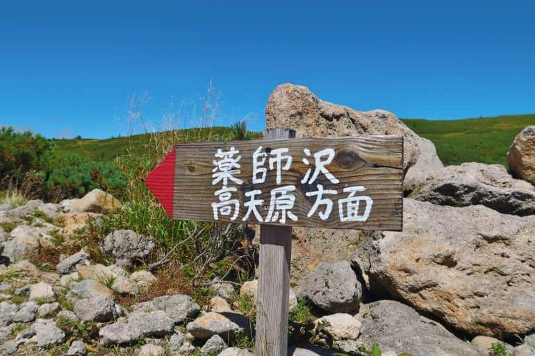
From the Tairodaira Hut, follow the path behind the hut heading south. After a few meters there’s a fork where you go left towards Yakushizawa.
The path descends fairly steeply into the valley, and the path crosses over a few streams on some bouncy bridges. It takes 2.5 hours to get to the Yakushizawa Hut (your Night 1 lodging).

Day 2
Cross over the bridge opposite the Yaukushizawa Hut and follow the path along the river a few meters until you see the sign for Kumonodaira, and head upwards. The path is quite steep, and quite difficult under foot with all the boulders. But at least you’re getting the hard part out of the way quickly. Eventually the path levels out to a fairly flat walk, with much of it on raised planks through open ground with great views.
Along the way are several stops with benches and, depending on the season, mountain flowers. Continue until you reach the Kumonodaira Hut, an exceptionally good mountain hut, with a panorama of the surrounding peaks. A great place to grab a bite (homemade bacon and rye bread, anyone?), listen to some jazz records (yes, they have a record player and floor standing speakers), and take in the spectacular views.
Next, back track down from Kumonodaira Hut about 50 meters, and follow the signs to Takamagahara taking the path directly north of the hut, up over the ridge and down the other side. The path then turns in a northwesternly direction, past a small communications mast, over some boulders and then eventually into a forest descending fairly steeply down towards the river. Be careful on this part of the hike as the path is across open ground and at times a little hard to follow. Keep your eyes peeled for colored markers on rocks. When in doubt, be safe and use an app (such as the above-mentioned YAMAP) to keep you on the right path.
When in the forest, you’ll make a fairly steep descent. Eventually you’ll reach a fork; follow the right path to the end of the descent, then over a couple of small bridges and fairly brief walk over to the Takamagahara Hut (your Night 2 lodging).
The hot spring is about a 20-minute walk from the hut, so check in, drop off your bags, and, finally, head over for a well-deserved soak.

The hot spring comprises a smaller rotemburo, or outdoor bath, (mixed genders), plus two covered baths—one for men, one for women. As this is Japan’s most remote hot spring, you won’t be surprised to learn there’s none of the customary washing areas complete with body soap and shampoo. Instead you can take a small bucket of water and give your body a quick rinse before bathing.
There’s also a mountain stream flowing alongside the outdoor bath should you fancy the hot/cold experience. Do watch out though as depending on recent precipitation the flow could be quite strong.
Day 3
Check with the hut staff that the river route is passable, as heavier precipitation may render the path impassable.
Retrace your steps back to the fork, and continue along the path heading to Yakushizawa. The path here is quite tricky, tracing around the mountain above the river. There are many steep ups and downs, sometimes with ladders and ropes, as you cross several creeks.
The path eventually descends and continues alongside the river. It’s a beautiful mountain stream, and you may be tempted to take a quick dip, but be warned, it is very cold and the current can be quite strong.
The river path terminates at the familiar Yakushizawa Hut, and the final leg is to retrace the journey you made on Day 1 back to Tairodaira hut.
Although it’s probably not possible to make it back to Oritate in time for the bus, you can easily make it down to Oritate well before 8 pm if you have alternative transport back to Toyama
Day 4
Retrace your steps from Day 1, and in approximately 3 hours you’ll be back to the Oritate car park. Don’t miss the bus!